
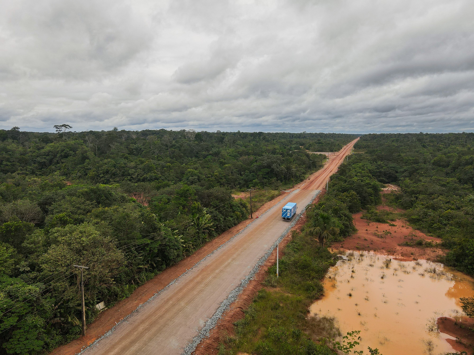
For much of his career, Carlos Santos' job involved being stranded in the middle of the Amazon. Santos is a truck driver on the BR-319, a hazardous dirt highway in Brazil that cuts through a critical part of the rainforest. "You knew when you were going in," he said of the road. "But you never knew when you'd come out the other side."
It once took Santos 22 days to cross the 540-mile route. An unexpected rain pounded the highway during the dry season, leaving large pools of mud that mired convoys of trucks. "It's a survival test in the jungle," he said. "Time moves slowly. You have to ration food and water." At night, Santos would hang a hammock in his truck cabin and watch as jaguars, tapirs, and snakes crossed the road in front of him. For weeks, he dug vehicles out of ditches, bathed in nearby rivers, and waited for heavy machinery to pull rigs from the mud one by one.
When he finally got home, Santos rested for a few days and then returned for another haul down the 319. "I went back because I enjoy it," he said. "It's one hell of a challenge."
But there's another reason such conditions are endured aside from a penchant for adventure. The BR-319 is the only road connecting the state of Amazonas, home to 4.2 million people and twice the size of Texas, to the rest of Brazil. Now, after decades of court battles and challenges by environmental groups and regulators, sections of the highway are being asphalted, and plans to pave the entire route are moving forward.
Asphalting the 319 is a long-held demand of many in the region, who feel their isolation hinders economic development. "Why should we be forgotten?" Santos asked. "Why doesn't the state of Amazonas have the right to be connected to the rest of the country?" But the decision isn't so straightforward. Scientists warn that paving the road will connect previously inaccessible regions of the Amazon to its most under-pressure areas, leading to a deforestation boom with dire consequences for the global climate. The biome currently holds an estimated 150 to 200 billion tons of carbon in its plants and soils, helping to offset greenhouse gas emissions from activities like burning fossil fuels. When the forest is cleared and burned, that stored carbon is released back into the atmosphere, fueling climate change. Indigenous groups that live in the area also say the project poses an existential threat to their communities.
This May, before the paving went into full swing, I joined Santos on his route to observe how the 319 and the forest it traverses are already changing. We met at 3 a.m. at a distribution center on the outskirts of Manaus, the capital of Amazonas and home to over 2 million people. Despite its isolation, Manaus is a major manufacturing hub, the legacy of tax incentives that have attracted industry since the 1960s. The vast majority of goods currently enter and leave the city by boat or by air. Proponents of asphalting the 319 argue this dependence raises costs, lengthens delivery times, and leaves the region vulnerable to river-navigation interruptions brought on by severe droughts, which have become more common.
Santos was born and raised in Manaus and has been driving a truck since he was 18 years old. "I was never a fan of being locked in a room in front of a computer," he said. Now 45, he is affable with an easy smile. His belly comes close to touching the steering wheel, and his trimmed salt-and-pepper beard matches the remaining hair on the sides of his head. A long career driving the potholed roads of Amazonas has left him with a bad back.
We pulled out of the distribution center in an immaculate bright blue semi-truck, smaller and more nimble than some of the larger rigs that are regularly seen stranded or capsized amid the mud of the 319. The truck belonged to Bemol, a leading retailer in the Amazon region, and carried large kitchen appliances, furniture, and medicine. Our destination was Porto Velho, the capital of Rondônia, which sits at the other end of the highway.
Santos has been driving on the 319 since 2015, when it reopened after decades of disrepair. Back then, he said, mud pools would stretch for dozens of yards during the rainy season, and potholes were the size of small craters. He was recounting this as we crossed the Rio Negro on a ferry, with dozens of other vehicles. The sun began to rise as we passed the famous meeting of the waters, where the dark, Coca-Cola-colored Rio Negro meets the murky brown Solimões, and the two rivers flow side by side without mixing. An hour later we were off the ferry and onto the highway. It would be a two-day trip with an overnight stop, but that was not guaranteed. The speed of travel on the 319 is highly dependent on the conditions of the road on any given day.
"You never know what to expect," Santos told me.
In many ways, the history of deforestation in the Amazon is a history of road-building. In the 1970s, Brazil's military dictatorship pursued an aggressive policy of constructing roads and encouraging settlement in the Amazon region. Since then, an area roughly the size of Spain has been deforested - 94 percent of which sits within 3 miles of a road. Often the mere possibility that a road will be built or paved is enough to increase deforestation in a given area.
The BR-319 was fully paved when it opened in 1976, but maintaining it proved too costly. It runs through a low-lying part of the forest and over the years, the grinding conditions of the rainy and dry seasons eroded the asphalt. Bus companies ceased service along the route, and businesses stopped using it to ship goods. The trees closed in on the highway and by 1988 it was virtually impassable, with only the ends still covered with asphalt.
For years it was left to the forest, used only by the handful of communities that still lived along its route and the occasional adventurer passing through. The trees blocked the sky for long sections of the road, and the wood bridges rotted away. In 2015, federal regulators issued a license for the cleanup and maintenance of the roadway, though not its repaving. Crews worked to clear the trees and repair the more than 50 bridges that run along the road. Conditions remained precarious, but traffic returned.
When Jair Bolsonaro was elected president in 2018, he gutted environmental regulations and announced he would pave the BR-319 once again. A far-right former army captain, Bolsonaro had campaigned on a platform friendly to loggers, miners, and agribusiness. The promise alone drove a 122 percent rise in deforestation in the area surrounding the highway between 2020 and 2022, greater than the already high deforestation rate for the Amazon as a whole during the same period.
Brazil's federal courts blocked the project due to inconsistencies in the environmental licensing process, but in 2025, years after Bolsonaro had left office, Brazil's pro-agribusiness Congress passed a law that said work on existing roads could bypass licensing altogether. President Luiz Inácio Lula da Silva, or Lula, tried to veto parts of the bill but was overruled by Congress. In May, the government opened bidding for paving contracts. "By the end of June," George Santoro, the Minister of Transportation, announced, "the entire BR-319 will be under construction."
After the ferry, the BR-319 continues on potholed asphalt for 120 miles, the final remnants of the original 1970s road. As we drove through the district of Careiro, the first on the 319 after Manaus, the landscape varied between forest and pasture, with modest, scattered homes on the side of the road. "Houses used to be a rare sight," said Santos. "You'd see one here and another way off in the distance. Not anymore."
It's typical of a region in the early stages of deforestation. First, speculators and loggers clear public land. Once the timber is extracted, ranchers move in. They might live on the land themselves, but often they'll hire someone to live there for them and tend the livestock. The ultimate goal is to petition the government for a formal land title which, if granted, can be resold once the road is fully paved and the land worth far more. The process of land regularization in Brazil is slow, bureaucratic, and rife with irregularities. Occupation is often a first step towards legal recognition, even when the initial clearing was illegal.
For three months in 2023, Manaus was shrouded in a thick cloud of smoke, ranking it among the cities with the worst air quality in the world. The governor of Amazonas at the time blamed the crisis on forest fires in the neighboring state of Pará. Research using satellite imagery and atmospheric data has since shown that while some of the smoke was indeed coming from Pará, much of it originated from forest-clearing blazes in districts at the start of the BR-319, like Careiro.
As the old asphalt continues, the pastures become less frequent and the landscape progressively more wild. Then, all of a sudden, the asphalt turns into a reddish, iron-rich clay. It's a surface that is rock-hard when dry and extremely slippery when wet. The rainy season brings mud and a slickness that causes trucks to glide out of control. The dry season brings clouds of dust that reduce visibility to just a few yards. This constant wetting and drying causes the dirt to form small ridges that drivers have come to call "cow ribs." They rattle trucks like never-ending rumble strips.
Compared to what the highway was like in the recent past, this is a minor nuisance. "For the veterans around here, the road is a cakewalk now," Santos said. The BR-319 may not be paved yet, but maintenance on the route has intensified in the past few years.
We encountered a road crew just a few miles after hitting dirt. To keep the highway passable, crews work daily on different sections, flattening uneven terrain, packing the ground, and adding gravel. Areas that easily flooded just a few years ago have been raised, bridges repaired or rebuilt entirely. (Environmentalists claim that much of this work goes beyond the maintenance license that was issued in 2015.) The road is still mostly used by trucks, but new companies can now be seen on the route, mostly transporting consumer goods, some coming from as far as São Paulo, 2,400 miles away.
Traveling the 319 with Santos means listening to an unbroken catalogue of accidents he's witnessed. A truck that rolled into a ravine here, dropping brand new washing machines into the river. Another that tumbled over there, spilling gallons of milk onto the road. Even today, it is not uncommon for Santos to encounter a capsized truck, sometimes more than one in a single journey.
As we ventured deeper down the highway, lush forest occupied both sides of the road. "It's every shade of green you could think of," Santos remarked. He had a point. One hectare of Brazilian Amazon holds more species of trees than all of the continental United States and Canada combined.
About eight hours in, we reached the settlement of Iguapó-Açu. The town is home to some 75 families who live in stilt houses with tin roofs. It serves as a final rest stop for truck drivers before they face the BR-319's middle stretch, where it cuts through 250 miles of dense forest with virtually nothing else around. Residents of Iguapó-Açu live on subsistence farming, fishing, and by operating a sluggish barge that drivers must take across a narrow river to continue on their way down the 319.
While waiting for the barge, I spoke to residents who were eating freshly-caught fish stew on the porch of one of the houses. Raimunda de Sá Assunção, 53, moved to the town as a child and still remembers when the road was paved. She also remembers the years when the road fell into disrepair, many families left, and the drive to the nearest hospital could take days. Now the drive can take as little as two hours. She remains skeptical whether the road will ultimately be paved. "My hair's turned white, and nothing's happened"