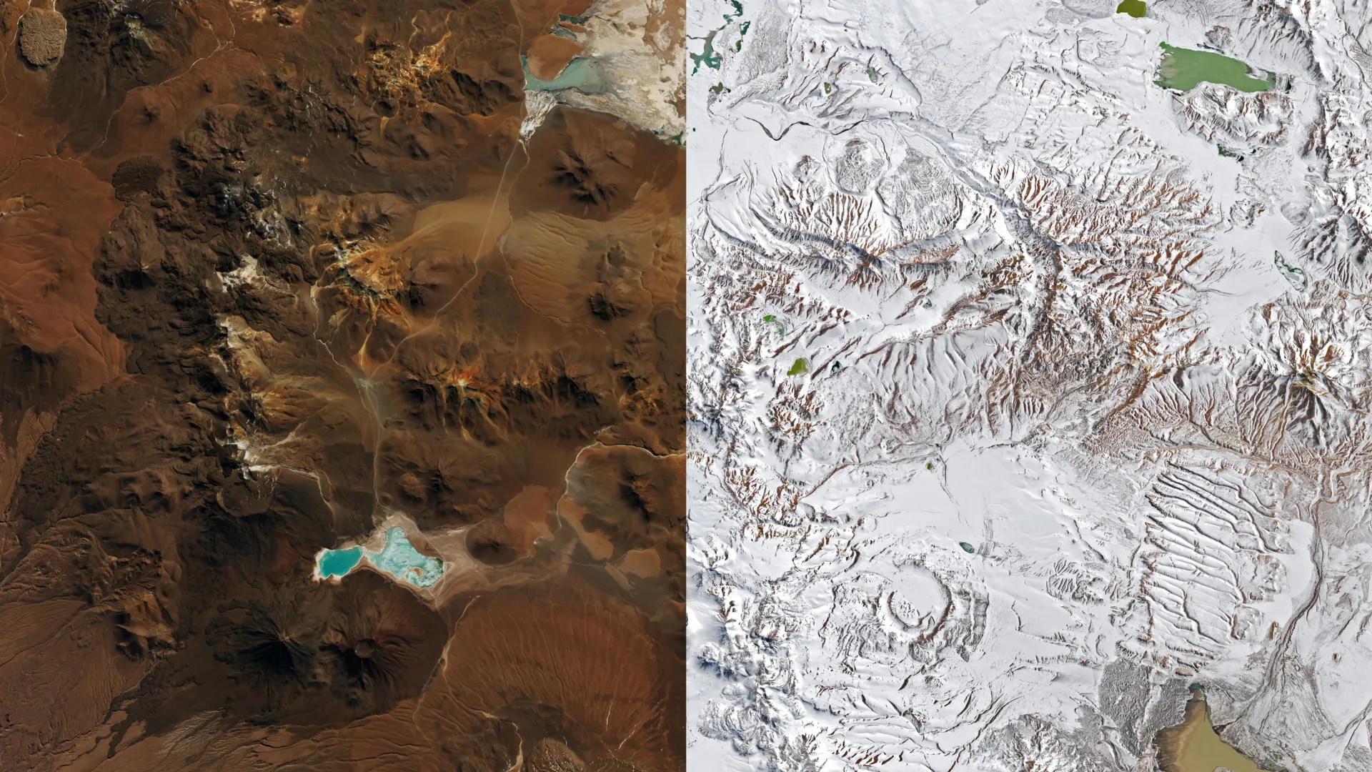
In a plot twist that feels like something out of a climate-change-themed soap opera, one of the driest places on Earth - the Atacama Desert in northern Chile - got a fresh dusting of snow in August 2026. Yes, you read that right. Snow. In the desert. The kind of event that's so rare, it's happened only a few times in recent memory, and now it's happened again, because why not?
The spectacle was captured by NASA's Landsat 8 and Landsat 9 satellites, which snapped before-and-after photos on August 6 and August 14, respectively. The images show the Chajnantor plateau, a high-altitude spot in the Altiplano-Puna volcanic complex, decked out in white. This area is home to the Atacama Large Millimeter/submillimeter Array (ALMA), one of the most powerful radio telescopes in the world. When the snow and winds hit, ALMA had to put its antennas into protective survival mode, which sounds like something from a sci-fi movie but is actually just a smart move to keep the equipment from freezing.
But the fun didn't stop there. A second storm later in August spread snow across an even larger swath of northern Chile, as seen in an August 19 image from NASA's Terra satellite. The snow stretched from the Andes, across the hyperarid heart of the Atacama, and nearly reached the Pacific coast south of Antofagasta. Several other major observatories in the region also suspended operations, because apparently, even the most advanced telescopes need a snow day sometimes.
What's behind this meteorological madness? Cutoff lows - low-pressure systems that break away from the jet stream - are the usual suspects. René Garreaud, an atmospheric scientist at the University of Chile, noted that a cutoff low caused a similar snowfall in 2025. But the August 2026 storm was special: it formed from an exceptionally large trough that stretched across a huge chunk of the Southern Hemisphere, from the tip of South America into the subtropics. Combined with moisture near the coast, this created precipitation across an unusually broad area, dumping rain and snow from offshore to the Andes. Garreaud said the totals reached levels "rarely seen in the otherwise extremely arid region."
Not all the precipitation was snow, though. In Taltal, nearly 40 millimeters (1.6 inches) of rain fell over three days - about 10 times the city's average annual rainfall. Garreaud noted, "We see these kinds of events only a few times, if any, per decade."
The downpour had serious consequences: mudflows and flash floods hit northern Chile, damaging hundreds of homes and affecting thousands of people, according to SENAPRED, the National Disaster Prevention and Response Service.
So why is this happening? Garreaud points to a strengthening El Niño as the backdrop. El Niño weakens the subtropical Pacific high that usually keeps the region dry, and makes it more likely for a blocking high to form near the southern end of the continent. Together, these changes shift the storm track closer to the equator, allowing wet weather to reach places that are typically parched. It's like Mother Nature decided to play a practical joke on the Atacama, and we're all just here to document it.
The Good Times
News in your inbox.
One sardonic roundup, delivered on your schedule. Free. Unsubscribe whenever your tolerance for wit runs out.
Already subscribed but we never reach your inbox? Check your spam folder and hit 'Not spam' (or 'Remove from spam') to bust us out of junk-mail purgatory. You'll be helping everyone else too.
Don't open any of our emails for a month and you'll be automatically removed from the mailing list.
Rewrite Article
Select parts to regenerate with a fresh AI pass. Translations will be updated automatically.
Generate AI Image
Creates a sardonic version of the article image using OpenAI.