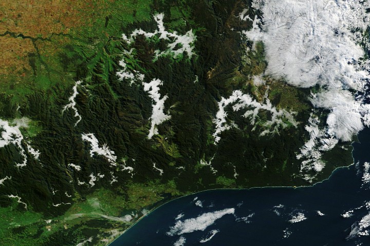
It's autumn in the Southern Hemisphere, which means the Victorian Alps have entered their annual fog-only fashion week. NASA's Terra satellite, clearly not one to miss a good atmospheric spectacle, captured morning fog filling valleys across several national parks in eastern Victoria back in May.
As nights get longer and the atmosphere gets more time to cool off and approach the dew point - that magical temperature where air gives up and turns water vapor into radiation fog - the laws of physics kick in. Cold air, being the dense, grumpy thing it is, sinks and drains into valleys, letting fog set up camp there first. In low-elevation areas, radiation fog usually fades when the Sun warms the ground, but mountain valleys stay shaded longer, so the fog gets to linger like an uninvited houseguest. On this particular day, geostationary satellite imagery shows the fog hung around for about two hours.
Fog, for those who haven't googled it, is basically a low-lying cloud made of tiny water droplets. The main difference between a cloud and fog is that fog's base touches the ground, while a cloud's base is generally well above the surface - so fog is essentially a cloud with commitment issues. Radiation fog forms in clear, calm conditions at night. In this case, a blast of cold, soggy weather primed the region by moistening land surfaces a few days before a slow-moving high arrived, bringing calmer, warmer conditions that were perfect for fog formation.
Many valleys in the mountains also have rivers, streams, and lakes, which made the whole process even more dramatic by providing a ready supply of water vapor. In the image, zones of fog have formed along several water bodies, including the Mitta Mitta River, Buffalo River, Livingston Creek, Lake Dartmouth, and Snowy River - basically a who's who of Australian waterways.
The same conditions fueled another noteworthy cloud a few hundred kilometers to the southwest. At about 8:19 a.m. local time (22:19 Universal Time), the Terra satellite captured an arch-shaped cloud over Port Phillip Bay, roughly stretching from St. Leonards on the bay's western shore to Mount Eliza on the eastern side. The feature likely formed as converging land and sea breezes interacted with the horseshoe-shaped terrain that defines the bay. Geostationary satellite imagery shows the arch-shaped cloud moving southward across the bay as the valley fog to the northeast faded, like a slow-motion atmospheric ballet.
NASA Earth Observatory image by Lauren Dauphin, using MODIS data from NASA EOSDIS LANCE and GIBS/Worldview. Story by Adam Voiland.
The Good Times
News in your inbox.
One sardonic roundup, delivered on your schedule. Free. Unsubscribe whenever your tolerance for wit runs out.
Already subscribed but we never reach your inbox? Check your spam folder and hit 'Not spam' (or 'Remove from spam') to bust us out of junk-mail purgatory. You'll be helping everyone else too.
Don't open any of our emails for a month and you'll be automatically removed from the mailing list.
Rewrite Article
Select parts to regenerate with a fresh AI pass. Translations will be updated automatically.
Generate AI Image
Creates a sardonic version of the article image using OpenAI.