California Island Earns Its 'North America's Galapagos' Nickname by Catching Fire
Santa Rosa Island, part of the 'North America's Galapagos,' burned through 16,600 acres in May 2026 after a human-caused fire threatened rare Torrey pines and forced a park closure.
Channel Islands National Park, the five-island chain off the coast of California that ecologists affectionately call “North America’s Galapagos,” recently demonstrated a less charming similarity to its equatorial namesake: a tendency to burn. For part of May 2026, Santa Rosa Island - the park’s second-largest landmass - was closed to the public as firefighters wrestled with a wildland fire chewing through grassland, coastal sage scrub, and island chaparral.
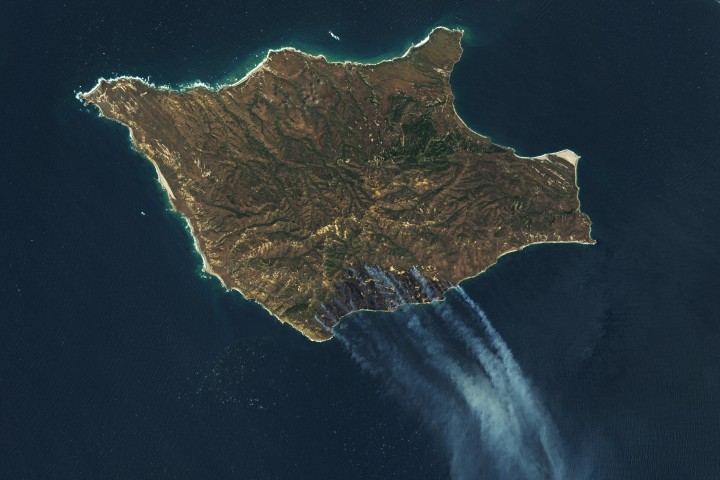
The fire was first spotted from an aircraft on May 15, 2026, and promptly confirmed by the National Park Service that morning. The Landsat 9 satellite, ever the diligent observer, captured images the next day showing the burned area had already swelled to 5,690 acres (2,300 hectares). By May 19, it had charred roughly 16,600 acres (6,700 hectares), consuming much of the island’s southeastern quadrant. Its perimeter, for now, remains defiantly uncontained.
One of the satellite images is a false-color composite, using wavelengths that cut through the smoke to reveal the scorched earth as a dark brown smear, with the actively burning fire front glowing orange in infrared. The companion image shows the same scene in natural color - because sometimes you need to see the smoke pouring over the Pacific Ocean to fully appreciate the situation.
Officials and local news accounts confirmed the fire was human-caused, though investigators were still trying to piece together exactly how someone managed to set the “Galapagos of North America” ablaze. The fire reportedly burned near a stand of Torrey pines - a rare tree species that, in the United States, grows naturally only on Santa Rosa Island and near San Diego. Because of course it does.
The Good Times
News in your inbox.
One sardonic roundup, delivered on your schedule. Free. Unsubscribe whenever your tolerance for wit runs out.
Already subscribed but we never reach your inbox? Check your spam folder and hit 'Not spam' (or 'Remove from spam') to bust us out of junk-mail purgatory. You'll be helping everyone else too.
Don't open any of our emails for a month and you'll be automatically removed from the mailing list.
Rewrite Article
Select parts to regenerate with a fresh AI pass. Translations will be updated automatically.
Generate AI Image
Creates a sardonic version of the article image using OpenAI.