Mars Once Had an Ocean, and This Chaotic Valley Is Basically the Drain
A 1,300-kilometer Martian valley gives scientists more evidence that Mars once had an ocean, because apparently being a dry, cold desert wasn't always the vibe.
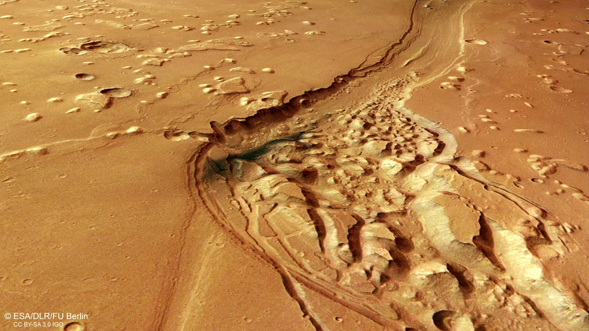
ESA's Mars Express mission is shining a spotlight on Shalbatana Vallis this month, an enormous Martian valley that looks like it had a very eventful past involving water, volcanoes, impact craters, and a serious case of surface collapse. Located near the equator of Mars, Shalbatana Vallis stretches roughly 1,300 kilometers - about the length of Italy, if Italy were a dry, dusty ditch on another planet.
The latest image from the spacecraft's High Resolution Stereo Camera (HRSC) focuses on the northern section of the valley as it winds across the landscape. In October 2025, Mars Express also released a video tour of this region, tracing the valley from its source in the highlands of Xanthe Terra to its endpoint in the smoother terrain of Chryse Planitia, presumably with a dramatic soundtrack.
Scientists believe Shalbatana Vallis formed around 3.5 billion years ago after vast amounts of groundwater burst onto the surface, causing floods that tore through the landscape and carved deep channels. The main valley visible in the image measures roughly 10 kilometers wide and reaches depths of around 500 meters - features especially clear in the accompanying topographic view, because nothing says 'ancient catastrophe' like a good topo map.
Researchers think the valley was once even deeper but got filled in over billions of years by various materials. One especially noticeable blue-black patch in the rougher section is believed to be volcanic ash redistributed by Martian winds, as seen in the accompanying 3D perspective views. So basically, Mars had volcanoes, floods, and wind - Earth's messy roommate.
Evidence of Water, Lava, and a Possible Ancient Ocean
Shalbatana Vallis is one of many outflow channels in this part of Mars, marking the transition between the heavily cratered southern highlands and the smoother northern lowlands. Nearby lies Chryse Planitia, one of the lowest regions on Mars, where many major outflow channels end. Some scientists suggest the area may once have contained a large ocean during a warmer and wetter period in Mars's history - because if you're going to have an ocean, you might as well put it at the bottom.
The area surrounding Shalbatana Vallis contains many additional geological features, including chaotic terrain - landscapes filled with broken blocks, ridges, and irregular mounds of rock. Scientists think this terrain formed when underground ice began melting, causing the ground above to shift and collapse. Similar chaotic landscapes have been observed by Mars Express in areas including Pyrrhae Regio, Iani Chaos, Ariadnes Colles, Aram Chaos, and Hydraotes Chaos - names that sound like a death metal band's tour schedule.
Numerous impact craters are also visible throughout the region, some sharply defined, others partially buried or eroded. Several are surrounded by ejecta blankets - debris blasted outward during impacts. The smoother appearance of much of the terrain suggests that lava once flowed across the region, cooling and contracting to produce 'wrinkle ridges' and isolated hills called 'mesas.' Just another day on a planet with a violent past.
More Than Two Decades of Mars Exploration
The image was captured by the HRSC camera, one of eight scientific instruments aboard Mars Express. Since launching in 2003, the spacecraft has spent more than 20 years studying the Red Planet and mapping its surface in color and in three dimensions at unprecedented detail. Data collected by Mars Express has significantly expanded scientists' understanding of Mars and its geological history - proving that if you point a really good camera at a dead planet for two decades, you learn a lot.
The Mars Express HRSC was developed and is operated by the German Aerospace Center (DLR), with camera data processing at the DLR Institute of Space Research in Berlin-Adlershof. Researchers at the Planetary Science and Remote Sensing group at Freie Universität Berlin used the data to create the image products shown here. Materials provided by European Space Agency (ESA). Note: Content may be edited for style and length.
The Good Times
News in your inbox.
One sardonic roundup, delivered on your schedule. Free. Unsubscribe whenever your tolerance for wit runs out.
Already subscribed but we never reach your inbox? Check your spam folder and hit 'Not spam' (or 'Remove from spam') to bust us out of junk-mail purgatory. You'll be helping everyone else too.
Don't open any of our emails for a month and you'll be automatically removed from the mailing list.
Rewrite Article
Select parts to regenerate with a fresh AI pass. Translations will be updated automatically.
Generate AI Image
Creates a sardonic version of the article image using OpenAI.