Antarctic Winter Ends, Volcano Still Showing Off Its Glowing Lava Lake
Satellite images show Mount Michael's persistent lava lake glowing through the Antarctic winter, because even volcanoes can't resist a little attention.
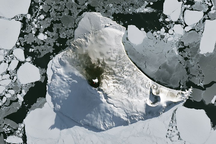
As the Antarctic Circle finally shook off months of frozen darkness, a satellite caught Mount Michael doing what it does best: being a volcano. The stratovolcano, nestled in the middle of Saunders Island, was spotted on August 24, 2026, by the NASA-USGS Landsat 8 satellite, which revealed that despite the icy surroundings, the mountain's summit crater is still home to a persistent lava lake. Because nothing says 'spring has sprung' like a glowing pit of molten rock.
The natural-color image, enhanced with infrared data (OLI bands 7-6-5) shown in red, highlights the heat signature of the lava lake, while a volcanic plume hovering over the peak and darkened snow on the northern slopes suggest the volcano is not just sitting there looking pretty - it's actively erupting, albeit modestly.
Saunders Island is part of the South Sandwich Islands, a chain of volcanic peaks about 350 kilometers (220 miles) long, formed by the South American plate subducting beneath the tiny South Sandwich plate. These islands have been erupting regularly for centuries, which is either a testament to geological persistence or a warning to anyone thinking of moving there.
Because these volcanoes are so remote, scientists rely on satellite data to keep tabs on them. By analyzing 30 years of thermal anomalies from Landsat, Sentinel, and ASTER observations, researchers concluded that Mount Michael hosts a persistent lava lake in its summit crater - a feature shared by only a handful of other volcanoes on Earth, including Kīlauea, Nyamulagira, and Erta Ale. So it's in good company, if 'good' means 'prone to spewing molten rock.'
Thermal data from MODIS and VIIRS instruments, processed through MIROVA's near-real-time hot spot detection system, indicate that low-intensity activity has been ongoing for years. Meanwhile, NASA's Aura satellite has noted that sulfur dioxide and other gas emissions are common at Mount Michael, because what's a volcano without a little toxic gas?
But the show wasn't over. A week later, when Landsat 9 passed over, the skies had clouded over, but the weather put on its own spectacle: the 843-meter-high (2,766-foot-high) peak disturbed passing winds, creating wave clouds that resemble a ship's wake - a familiar sight in these parts. And NASA's Aqua satellite spotted a volcanic track from degassing sulfur dioxide, just in case anyone thought the volcano was taking a break.
So while the rest of the Antarctic region may have been hunkering down for the winter, Mount Michael was busy being a beacon of geological activity, proving that even in the most desolate places, there's always something glowing.
The Good Times
News in your inbox.
One sardonic roundup, delivered on your schedule. Free. Unsubscribe whenever your tolerance for wit runs out.
Already subscribed but we never reach your inbox? Check your spam folder and hit 'Not spam' (or 'Remove from spam') to bust us out of junk-mail purgatory. You'll be helping everyone else too.
Don't open any of our emails for a month and you'll be automatically removed from the mailing list.
Rewrite Article
Select parts to regenerate with a fresh AI pass. Translations will be updated automatically.
Generate AI Image
Creates a sardonic version of the article image using OpenAI.