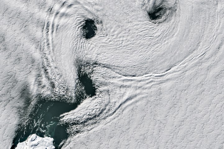
NASA Captures Clouds Doing Their Best Impression of a Van Gogh Painting Near Antarctica
NASA's Landsat 8 captures stunning vortex clouds spiraling off a remote Antarctic volcano, proving that even in the Screaming Sixties, the atmosphere has a sense of style.
Over the Southern Ocean surrounding Antarctica, winds can whip around the globe relatively unimpeded by land - no pesky continents to get in their way. Intrepid sailors, presumably with a flair for the dramatic, termed these southern latitudes the Roaring Forties, Furious Fifties, and Screaming Sixties on account of the strong prevailing winds. The names suggest a weather system that's been hitting the gym and isn't afraid to show it.
When those winds encounter a barrier like an island, the disruption in airflow can be beautiful - a silver lining to the cloud of, well, actual clouds. One impediment, shown here, is remote Peter I Island. This ice-cloaked volcano lies at 68.86 degrees south latitude in the Bellingshausen Sea, some 400 kilometers (250 miles) off the coast of West Antarctica and more than 1,800 kilometers (1,100 miles) from Cape Horn, Chile. It's the kind of place you'd go to if you really, really wanted to be alone.
On an austral summer day in 2026, the Landsat 8 satellite captured this image of von Kármán vortex streets downwind of the island. These counterrotating spirals form as flowing air is deflected, slows, and spins into eddies - nature's version of a slow-motion spin cycle. A stiff, but perhaps not quite “screaming,” wind was likely blowing that day. Wind speeds typically need to be 18 to 54 kilometers (11 to 34 miles) per hour for vortices to form. With stronger gales, the eddies cannot maintain their shape - they're like a soufflé in a hurricane. The following day, vortex streets appeared within a complex array of cloud types near the island, as if the atmosphere was showing off.
Where the clouds parted around the island, some of its icy edifice became visible to the satellite. A 100-meter-wide circular crater sits at its summit, 1,640 meters (5,380 feet) above sea level. The Smithsonian Institution's Global Volcanism Program describes the island as a “shield-like volcano,” but there are no records of recent eruptions. So it's either dormant, or just very, very shy about its volcanic activity.
Scientific research on Peter I Island has been limited due to its remote location and the challenging ice conditions surrounding it - basically, it's a pain to get to. The island was discovered in 1821 by the Russian explorer Fabian Gottlieb von Bellingshausen and named for a tsar, but no one landed on it until 1929. That's over a century of people saying, "Yeah, we see it, but let's not get too close." The relatively few studies since have focused on geology, biodiversity, and the climate history recorded in its ice - the usual suspects for a frozen, isolated rock.
NASA surveyed the island during an Operation IceBridge campaign in 2011. This airborne science mission collected a suite of measurements over Earth’s polar ice in the period between the ICESat and ICESat-2 satellite missions to sustain the record of observations in these regions. While NASA’s DC-8 aircraft flew back to Chile from Antarctica, where teams spent the day measuring the Getz Ice Shelf and Thwaites Glacier from the air, the crew on board caught a rare glimpse (above) of the remote island. It's the kind of view that makes you forget you're in a cramped plane for a moment.
The Good Times
News in your inbox.
One sardonic roundup, delivered on your schedule. Free. Unsubscribe whenever your tolerance for wit runs out.
Already subscribed but we never reach your inbox? Check your spam folder and hit 'Not spam' (or 'Remove from spam') to bust us out of junk-mail purgatory. You'll be helping everyone else too.
Don't open any of our emails for a month and you'll be automatically removed from the mailing list.
Rewrite Article
Select parts to regenerate with a fresh AI pass. Translations will be updated automatically.
Generate AI Image
Creates a sardonic version of the article image using OpenAI.