
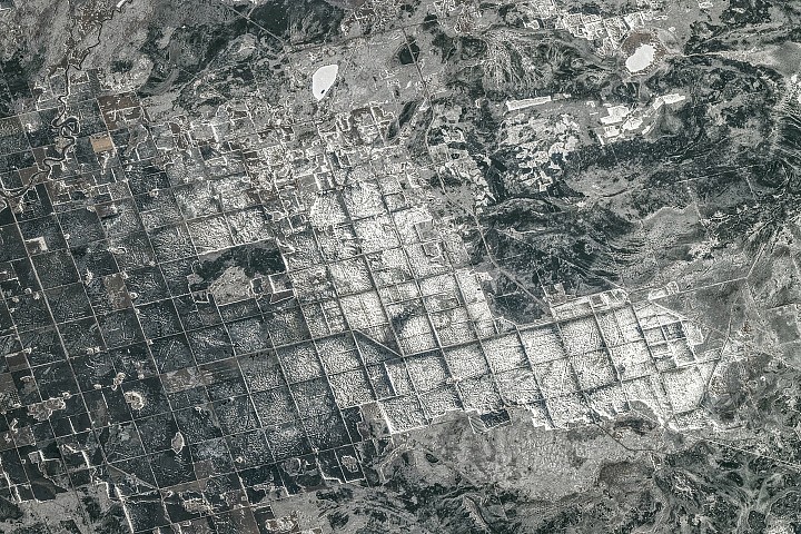
About 15,000 years ago, southeastern Manitoba was not a great place for a beach vacation. It sat beneath tens of meters of frigid water in Lake Agassiz - a body of water so massive it covered an area larger than all the Great Lakes combined, stretching 1,100 kilometers long and 300 kilometers wide across parts of today's Manitoba, Ontario, Saskatchewan, North Dakota, and Minnesota. Formed in front of the retreating Laurentide Ice Sheet, which dammed rivers that might have drained into Hudson Bay, Lake Agassiz was basically nature's way of saying, "You're not ready for farming yet."
The lake began draining roughly 12,000 years ago, but its legacy remains visible - and profitable. In April 2026, an astronaut aboard the International Space Station photographed farmland along the southern shore of Lake Winnipeg, where Lake Agassiz deposited a thick, nearly flat bed of nutrient-rich silt and clay. Those former lakebed areas now support some of Canada's most productive agricultural landscapes, because nothing says "good soil" like millennia of sediment settling.
A grid-based land survey has also left its mark. The Dominion Land Survey - one of the world's largest and most systematic surveying efforts - divided much of western Canada into one-square-mile sections after the Canadian government purchased Rupert's Land from the Hudson's Bay Company in 1869. The grid continues to define farm fields, roads, shelterbelts, and drainage channels, proving that 19th-century bureaucracy has a surprisingly long shelf life.
When the photo was taken late in the afternoon on April 19, a layer of snow and ice covered the landscape. The brightest, whitest blocks appear to be snow-covered farmland or icy ponds, while darker areas are forests, wetlands, or exposed ground with less uniform snow cover - basically, a winter wonderland with crop potential.
Wheat, barley, oats, and canola are among the crops often grown in the area. In the upper part of the image, cottages and lake houses cluster around Gull Lake, a popular site for boating, fishing, and water sports. Common fish species include northern pike, walleye, and yellow perch, because even the fish here are practical.
Astronaut photograph ISS074-E-494130 was acquired on April 19, 2026, with a Nikon Z9 digital camera using a focal length of 560 millimeters. It's provided by the ISS Crew Earth Observations Facility and the Earth Science and Remote Sensing Unit at NASA Johnson Space Center, taken by a member of the Expedition 74 crew. The image has been cropped and enhanced to improve contrast, and lens artifacts removed - because even NASA photos need a little airbrushing. The International Space Station Program supports the lab as part of the ISS National Lab to help astronauts take pictures of Earth of greatest value to scientists and the public, and to make those images freely available on the Internet. Additional images can be viewed at the NASA/JSC Gateway to Astronaut Photography of Earth. Story by Adam Voiland.