Guinea-Bissau's Bijagós Archipelago: Where Tides Do All the Work, Biodiversity Reaps the Rewards
Tides in Guinea-Bissau's Bijagós Archipelago create a biodiversity bonanza, with 870,000 migratory birds and less-than-1%-surviving baby turtles - because nature doesn't do participation trophies.
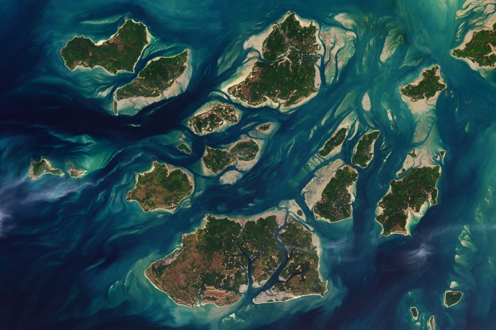
Twice a day, the tides in Guinea-Bissau's Bijagós Archipelago do their thing - ebbing and flowing through a maze of sandy channels, mudflats, and mangrove forests that flank 88 islands and islets. From above, the show is dramatic: at low tide, intertidal flats emerge, making islands grow before they shrink back hours later. It's like a magic trick, but with mud and water.
This perpetual tidal rhythm sustains an explosion of marine life in an archipelago that, in 2025, earned UNESCO World Heritage status. The site protects the only active deltaic archipelago on Africa's Atlantic coast, where tides, river sediments, coastal upwelling, and currents conspire to create unusually productive and biodiverse island ecosystems. Basically, it's a party for plankton and the creatures that eat them.
UNESCO estimates the islands support some 870,000 migratory shorebirds, making this a top feeding spot for birds along the East Atlantic Flyway. Hundreds of bird species feast on marine worms, crustaceans, mollusks, and small fish exposed by low tides. When the water rises, manatees, dolphins, and schools of fish move closer, pushing into mangrove forests, while tens of thousands of sea turtles swim inland to sandy beaches looking for nesting sites. It's like a marine traffic jam, but with more flippers.
A huge population of green sea turtles nests on the tiny island of Poilão, part of the João Vieira and Poilão Marine National Park. After hatching, baby turtles make perilous nighttime dashes to the sea, pursued by crabs, lizards, and birds. Once in the water, they face jacks, barracudas, groupers, snappers, tuna, mackerel, sharks, and rays. According to some estimates, less than 1 percent of green sea turtle hatchlings survive to adulthood. The odds are worse than a startup's IPO.
A 2025 analysis of the region's tides revealed why the archipelago has some of the largest tidal ranges in West Africa. The researchers concluded that the wide, shallow shelf and estuary geometry combine to create a tidal range of up to 7 meters (23 feet), compared to about 1 meter (3 feet) elsewhere. They used altimetry data from NASA/CNES satellites TOPEX/Poseidon, Jason-1, and Jason-2 to validate their findings. Because of course they did - NASA's satellites have better things to do than watch tides, but we appreciate the effort.
NASA Earth Observatory images by Lauren Dauphin, using Landsat data from the U.S. Geological Survey. Story by Adam Voiland.
The Good Times
News in your inbox.
One sardonic roundup, delivered on your schedule. Free. Unsubscribe whenever your tolerance for wit runs out.
Already subscribed but we never reach your inbox? Check your spam folder and hit 'Not spam' (or 'Remove from spam') to bust us out of junk-mail purgatory. You'll be helping everyone else too.
Don't open any of our emails for a month and you'll be automatically removed from the mailing list.
Rewrite Article
Select parts to regenerate with a fresh AI pass. Translations will be updated automatically.
Generate AI Image
Creates a sardonic version of the article image using OpenAI.