Astronaut Spots Greenbelt From Space, Confirms It Is, In Fact, Green
NASA releases a photo from space proving that a place called Greenbelt is, indeed, quite green, featuring parks, a historic New Deal community, and a space flight center.
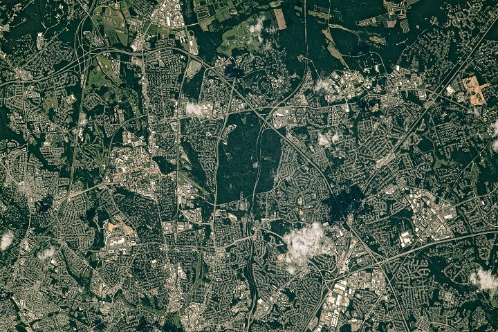
An astronaut on the International Space Station, presumably taking a break from more cosmic duties, recently snapped a photo of the Capital Beltway's northeast side as it passes through Greenbelt, Maryland. The image, captured on July 30, 2023, conveniently coincides with the time of year when plants do their whole 'being green' thing.
One of the standout green spaces is the aptly named Greenbelt Park, a 5-square-kilometer (2-square-mile) area containing trails, picnic spots, and a campground. The land, once eyed for city expansion, was acquired by the National Park Service in 1950, preserving it for future generations of hikers and picnickers.
Just north of the park lies Greenbelt's historic district, a crescent-shaped community born from the 1930s New Deal program. It was designed to provide work and affordable cooperative housing with accessible green space, connecting homes via walking paths to one of the nation's oldest planned shopping centers - a utopian vision with sidewalks.
East of the beltway sits NASA's Goddard Space Flight Center, established on May 1, 1959, as NASA's first spaceflight complex. Forested patches separate its buildings, while the large green spaces north in Beltsville are a mix of forest and agricultural fields belonging to the University of Maryland and USDA research sites. The university's main campus in College Park is visible just west of Greenbelt.
Other verdant areas include Hyattsville, south of College Park, recognized as a 'tree city' for over 30 years, and the tree-lined Baltimore-Washington Parkway (MD-295), which bisects Greenbelt Park. The photo, ISS069-E-39302, was taken with a Nikon D5 digital camera using a 1150-millimeter lens by an Expedition 69 crew member, then cropped and enhanced for our viewing pleasure.
The Good Times
News in your inbox.
One sardonic roundup, delivered on your schedule. Free. Unsubscribe whenever your tolerance for wit runs out.
Already subscribed but we never reach your inbox? Check your spam folder and hit 'Not spam' (or 'Remove from spam') to bust us out of junk-mail purgatory. You'll be helping everyone else too.
Don't open any of our emails for a month and you'll be automatically removed from the mailing list.
Rewrite Article
Select parts to regenerate with a fresh AI pass. Translations will be updated automatically.
Generate AI Image
Creates a sardonic version of the article image using OpenAI.