Glooscap's Stone Canoe or Glacial Scouring? Geologists Weigh In on Maine's Coastal Personality Crisis
Maine's shoreline goes from sandy to jagged, and while Glooscap had a stone canoe, geologists blame glaciers and bedrock - plus, lobsters and oysters reap the benefits.
The Wabanaki people have long explained Maine's jagged coastline with tales of Glooscap, a magical figure who floated down the Bay of Fundy in a stone canoe, sculpting coastal features and brawling with giant beavers, frogs, and whales. But for the less mythologically inclined, coastal geologists offer a competing narrative involving glaciers, bedrock, and a whole lot of sediment.
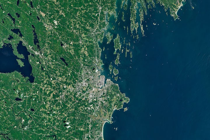
Southern Maine flaunts sandy beaches and sprawling salt marshes, thanks to broad deposits of sand sourced from rivers like the Saco, which carried weathered White Mountain material to the coast. Waves and tides then sculpted these soft sediments into the arch-shaped embayments seen around Saco Bay. East of Portland, however, metamorphic bedrock takes over, with ridges and valleys scoured by glaciers during the last ice age and later flooded as the Laurentide Ice Sheet melted. The result: a jagged, highly indented shoreline dotted with narrow islands, which geologist Nicholas Whiteman attributes to "the tortured folds of old landscapes" setting up a "sharp directional preference for erosion."
These coastal contrasts aren't just geological eye candy - they shape Maine's economy. Tourists flock to sandy Saco and Kennebunkport, while the state's iconic lobster fisheries thrive in the cold, rocky inlets of Midcoast Maine, making Harpswell a leader in lobster landings. Oyster farms also cluster in sheltered estuaries like Casco Bay and the Damariscotta Estuary, where waters offer a range of temperatures and salinities that produce oysters with distinct "merroir." Researcher Tom Kiffney of the University of Maine is using Landsat satellite data to predict oyster growth rates and pinpoint prime locations for new farms, presumably without any help from Glooscap.
The Good Times
News in your inbox.
One sardonic roundup, delivered on your schedule. Free. Unsubscribe whenever your tolerance for wit runs out.
Already subscribed but we never reach your inbox? Check your spam folder and hit 'Not spam' (or 'Remove from spam') to bust us out of junk-mail purgatory. You'll be helping everyone else too.
Don't open any of our emails for a month and you'll be automatically removed from the mailing list.
Rewrite Article
Select parts to regenerate with a fresh AI pass. Translations will be updated automatically.
Generate AI Image
Creates a sardonic version of the article image using OpenAI.