
Every year, millions of visitors to Grand Canyon National Park stop at a water station, blissfully unaware that their hydration depends on a cave-fed spring called Roaring Springs on the North Rim - a spot so inaccessible there's no trail to it. This single source supplies not just tourists but also the plants, animals, and entire ecosystems that call the canyon home. And as the region gets hotter and drier, protecting this vital water source is becoming increasingly important, because nothing says 'vacation' like a drought-induced water crisis.
Researchers at Northern Arizona University's School of Informatics, Computing, and Cyber Systems are on the case, trying to understand how Roaring Springs and other cave-fed springs actually work. With a new grant from Grand Canyon National Park, they'll expand efforts to map these water systems and figure out how snowmelt connects to the springs. "Understanding where the water sinks is critical for the infrastructure, the animals, the plants and the rest of the ecosystems that rely on these springs," said Blase LaSala, a Ph.D. student in ecoinformatics. "They're like oases." Early findings were recently published in Scientific Reports, because apparently even cave water deserves peer review.
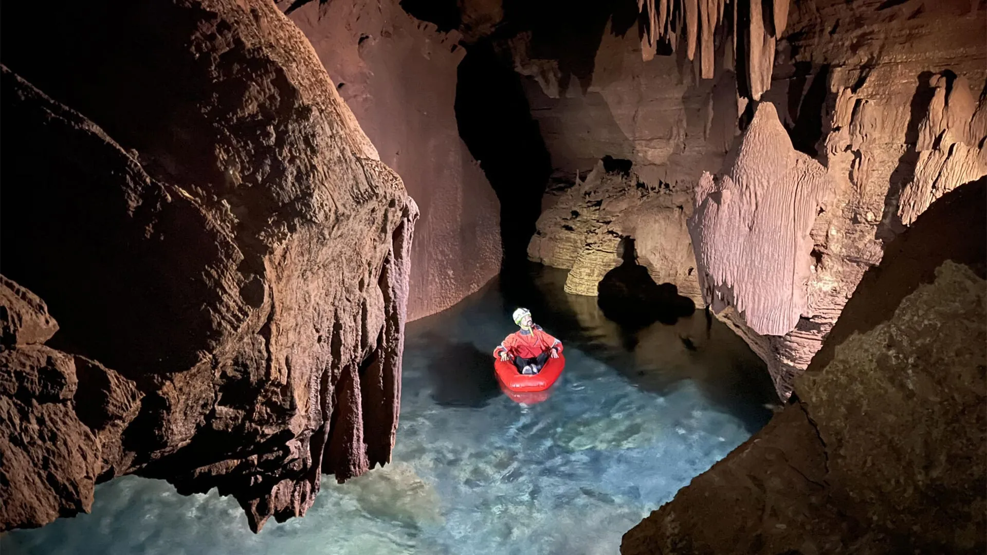
Most people will never enter the caves that feed Grand Canyon springs - they're closed to the public and often located far from established trails. So scientists have to get creative. For his doctoral research, LaSala worked with professor Temuulen "Teki" Sankey, an expert in remote sensing, to create detailed maps of several cave systems. Using a mobile lidar scanner, the team produced high-resolution 3D models capturing cave walls, ceilings, passages, and chambers in remarkable detail. Over 45 days, researchers, volunteers, and park staff documented more than 10 kilometers of underground passages and rooms. "I had no idea how large and long these caves are," Sankey admitted. "Grand Canyon's caves have never been mapped in 3D like this." The work required major logistical effort: team members carried packs weighing up to 55 pounds, including lidar equipment, while hiking to remote cave entrances that could take as long as two days to reach. Once inside, they climbed, rappelled, crawled, and even floated through flooded sections while recording the caves' shapes and fracture patterns. Casual Thursday, really.
The simplest explanation for where the water comes from is snowmelt from the Kaibab Plateau. The harder question is how that water travels underground before emerging at springs like Roaring Springs. The cave-fed springs are located within Redwall and Muav limestone formations, with several rock layers between them and the surface. Previous dye tracing experiments by the park have shown that water can move surprisingly quickly - in some tests, dye poured into sinkholes on the plateau traveled roughly 20 kilometers and appeared at springs in as little as a week. Exactly how it moves remains uncertain, with fractures, faults, rock permeability, and underground pathways all playing a role. "It's like looking at a black box," LaSala said. "You see what comes in and what comes out, but it's very hard to quantify what's going on in there."
Understanding these pathways isn't just academic: it's got practical implications for water quality and public safety. The Grand Canyon's largest springs are fed by karst systems, which Sankey compares to "Swiss cheese" because of the numerous holes, channels, and openings in the rock. Water moves rapidly through these pathways, leaving little opportunity for natural filtration - meaning contaminants like wildfire runoff or E. coli could travel quickly too. If contamination is detected, park officials may temporarily shut down pumping operations until the issue is addressed. By identifying where water enters the system and tracing how it moves, researchers can help managers pinpoint contamination sources and reduce the risk of future disruptions. The next phase of the project starts in early 2026, using airborne lidar surveys and satellite observations over several decades to map sinkholes and examine snow accumulation and snowmelt patterns over the last 40 years. Because Arizona has experienced declining snow levels over time, and the Grand Canyon region has followed the same trend - a problem that's not going to solve itself.
The research directly benefits Grand Canyon National Park, but its significance extends beyond Arizona: more than one billion people around the world rely on water from karst springs. Improving scientists' understanding of these complex underground systems could inform water management globally, and may also prove valuable for Native American tribes located within or near the park. "It's exciting to find patterns that verify the hypotheses made over 50 years ago," LaSala said. "We have all this amazing data now, and we're trying to combine it with other data to find useful things. There are so many places that could benefit from this type of analysis." As for the Dragon Bravo Fire, which is expected to influence future observations, both LaSala and Sankey view it as another factor to incorporate into their work rather than an obstacle. "It's a new twist to our study," Sankey said. Because in science, as in life, you adapt - or you run out of water.